By the middle of May 1863, Major General Ulysses S. Grant was loose in the interior of Mississippi, and there was no good way for the Confederacy to put him back. He had crossed the great river south of Vicksburg, cut himself free of his own supply line, and marched inland, winning a string of fights: Port Gibson, Raymond, and then the state capital at Jackson, which he wrecked and left smoking behind him. Now he turned west. Twenty miles (32 km) in front of him, behind the last good defensive ground before the fortress city, waited the army that was supposed to stop him.
Western TheatreVicksburg: the campaign Champion Hill belongs toThe whole point of all this marching was to take Vicksburg, and the whole point of taking Vicksburg was to break the Confederacy in half. Vicksburg held the last stretch of the Mississippi River still in Southern hands. Cut it, and the slaveholding states west of the river (Texas, Arkansas, most of Louisiana) would be severed from the rest of the rebellion. The rebellion was, at bottom, a slaveholders’ republic: the Confederacy had broken away from the United States to protect the enslavement of four million Black people, and Grant’s campaign was a campaign to saw that republic in two. The ground he was about to fight over made the point plainly. Champion Hill took its name from the Champion family, whose plantation it sat on, land in a Mississippi county worked by enslaved people, the very institution the South had seceded to defend. Every mile Grant pushed west, that institution dissolved behind his army: thousands of enslaved people had been freeing themselves along his line of march, walking off the plantations toward the Union columns rather than waiting to be freed.
The man waiting for him was Lieutenant General John C. Pemberton (South), commander of the Confederate army charged with holding Vicksburg. Pemberton had been handed contradictory orders: told both to hold the city at all costs and to march out and strike at Grant’s supply line, a supply line Grant had already abandoned, so the order chased a thing that no longer existed. Caught between the two, Pemberton had marched his army out of Vicksburg’s safe works (its ring of defensive fortifications) and into the open, and now he was strung along a low ridge with Grant bearing down on him.
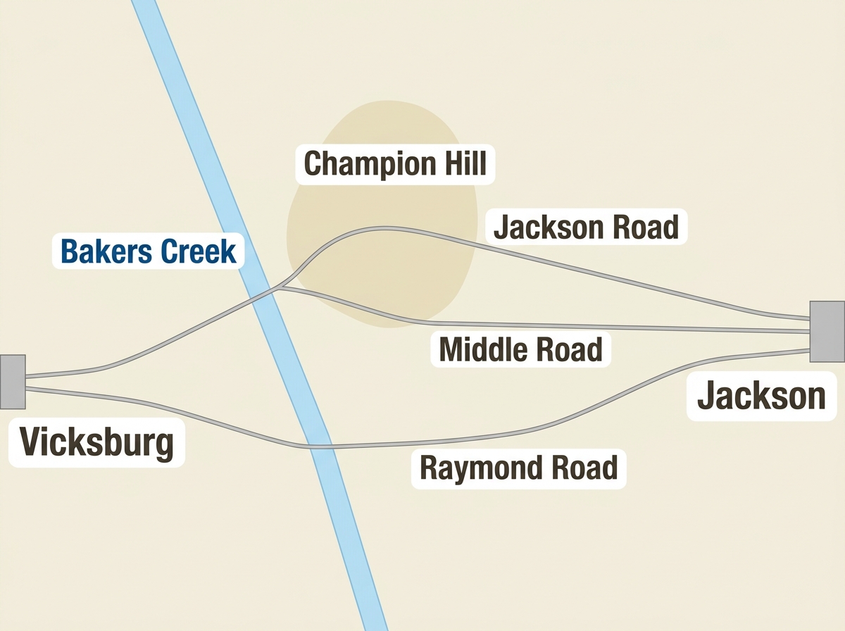
The ridge ran for about three miles, and it covered three roughly parallel roads, all running east to west, all leading back from the Jackson and Edwards Station area toward Vicksburg. From north to south they were the Jackson Road, the Middle Road, and the Raymond Road. Hold those three roads and you held the army’s way home. And the key to the three roads was a single piece of ground at the northern end: a bald crest about seventy-five feet high, rising over the country around it. This was Champion Hill. Grant, who saw the position that morning, judged it shrewdly chosen.
“...where Pemberton had chosen his position to receive us, whether taken by accident or design, was well selected. It is one of the highest points in that section, and commanded all the ground in the range.”
Grant, Personal Memoirs
The hill mattered because of what sat just below it. Where the Jackson Road and the Middle Road came together, perhaps a third of a mile down from the crest, there was a crossroads, and that crossroads sat astride Pemberton’s only good road back to Vicksburg. Whoever held the crossroads held the road home, and the crossroads belonged to whoever held the hill above it. The battle for Champion Hill was a battle for a road junction, and behind the road junction was a creek, Baker’s Creek, that the Confederate army would have to get across to escape. (The battle is sometimes called Baker’s Creek for that reason.) Lose the hill, lose the crossroads; lose the crossroads, lose the way over the creek; lose the way over the creek, and you lose the army.
A Near-Even Fight
On paper Grant had the bigger army, something on the order of thirty-two thousand men against Pemberton’s twenty-two or twenty-three thousand. Almost none of that edge would reach the field. A Civil War army was built in nested blocks: a handful of regiments made a brigade, a few brigades made a division, and several divisions made a corps, the largest building block of all, ten thousand men or more, the chunk a general like Grant moved around the map like a single piece. Grant had three corps in the area, and on this day two of them barely fought. Major General William T. Sherman’s (North) corps was still back at Jackson, out of range entirely. And Major General John A. McClernand’s (North) corps, marching up on the two southern roads, would sit nearly idle all day despite Grant’s orders, barely firing a shot. That left the fighting to fall on Major General James B. McPherson’s (North) corps and Brigadier General Alvin P. Hovey’s (North) division, a force just about equal in strength to Pemberton’s whole army. Champion Hill was a near-even, savage fight, and Grant won it not by weight of numbers but by where he landed the blow.