A world war began as a property scheme. Not over a throne, not over a religion, but over a stretch of rich river-bottom land west of the mountains that a handful of Virginia gentlemen meant to buy cheap and sell dear. They never lived there. The people who did live there, Shawnee and Delaware and Mingo and Wyandot families, had already moved once to get away from men exactly like these. The gentlemen formed a company, won a king's signature on hundreds of thousands of acres, and the rest of the continent's empires answered. By the time the shooting started, the deal had a name on it in two languages and a fort going up on the very spot the company's paperwork demanded.
The land everyone wanted and no empire held
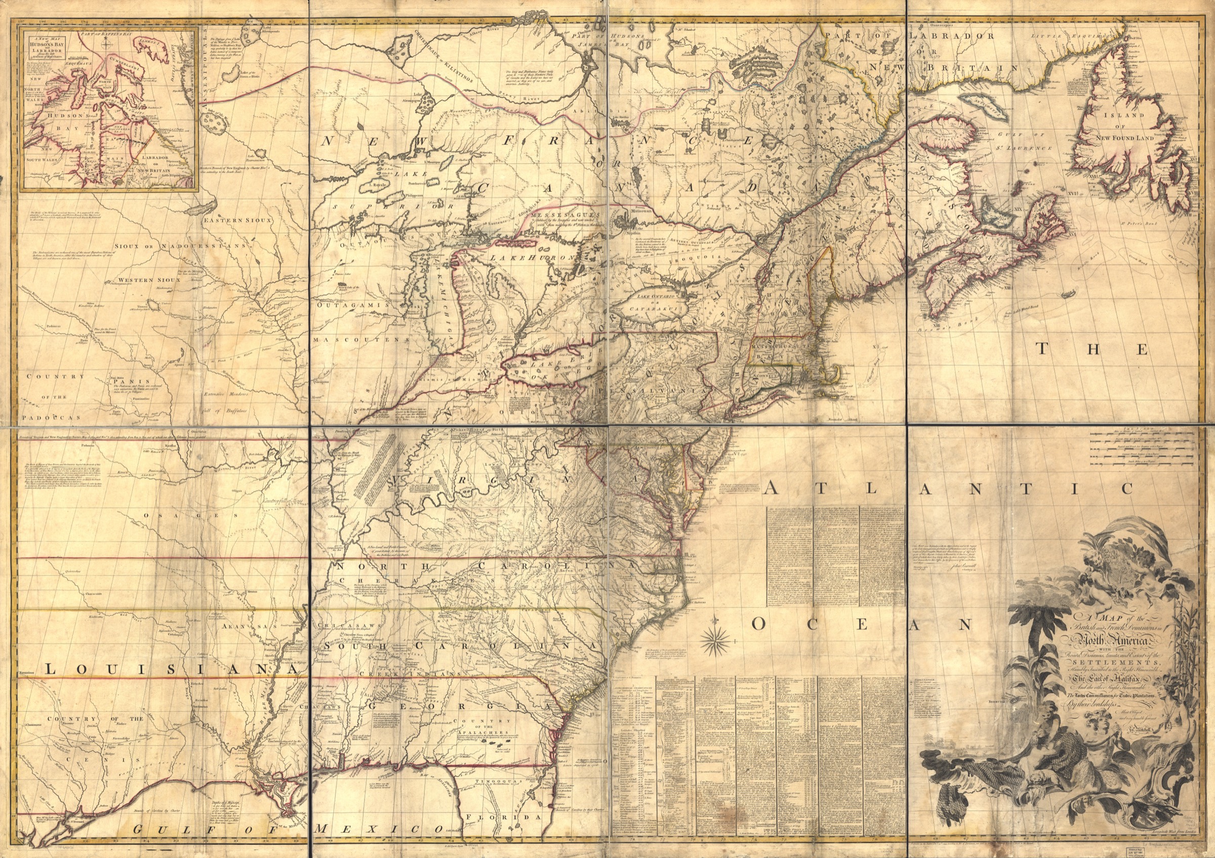
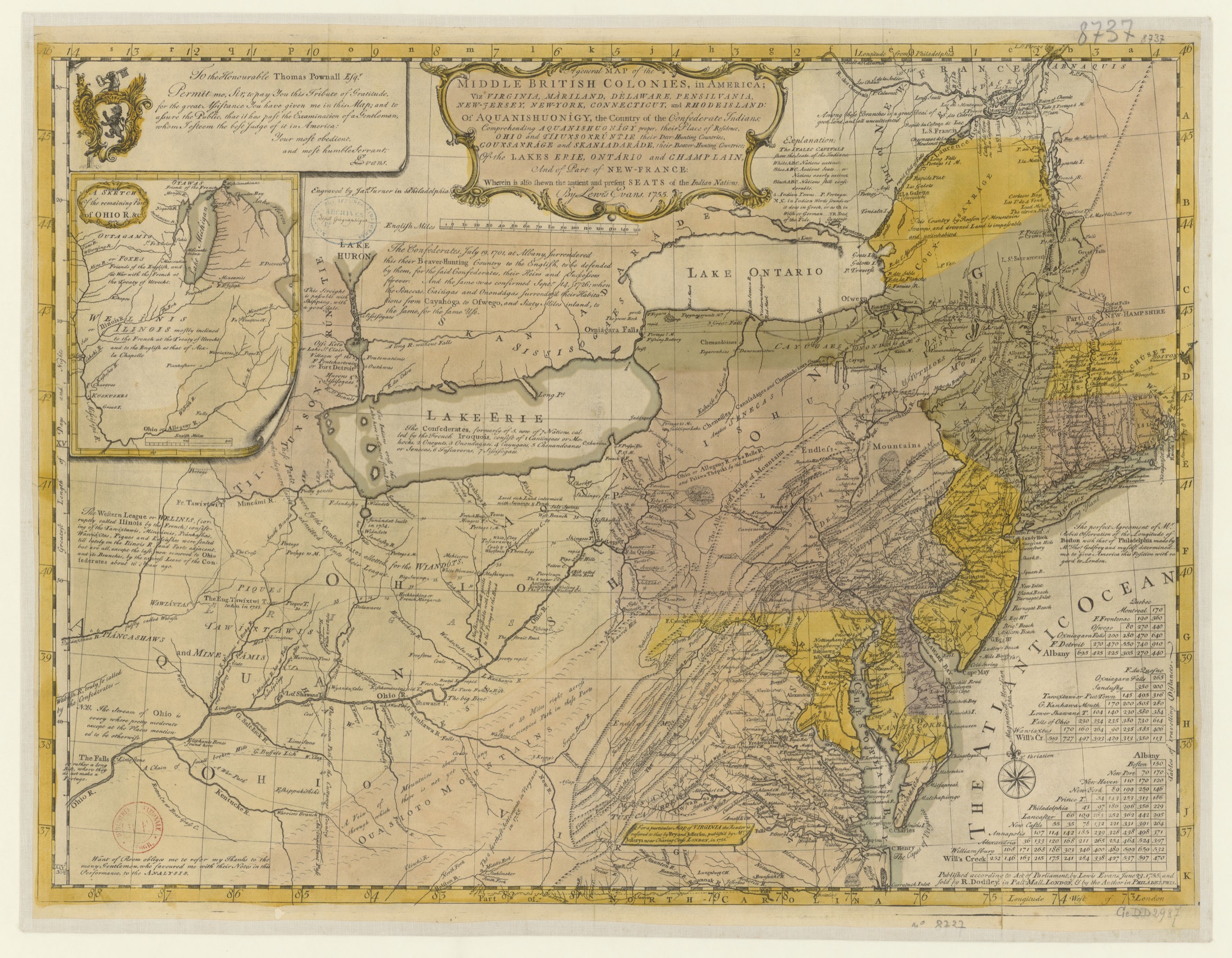
The Ohio Country was a loosely drawn region west of the Appalachian Mountains and south of Lake Erie, the upper valley of the Ohio River. A trader's map from 1752 ran its rough edges from the Wabash River in the west to the Thirteen Colonies in the east, Lake Erie in the north, the Cumberland River in the south. To a tidewater planter in coastal Virginia it was the best unclaimed farmland on the continent. To France it was something more vital: the land bridge. New France ran in a long arc, from Canada and the St. Lawrence River in the north down through the Illinois Country to Louisiana and the mouth of the Mississippi in the south, and the Ohio valley was the hinge that held the two ends together. A wall of British farms planted across that valley would saw New France in half.
So both empires drew the Ohio Country onto their maps in their own colors. Neither one lived there.
The people who lived there were Native nations. A century earlier, in the 1600s, the Iroquois Confederacy (the powerful alliance of Native nations based in what is now upstate New York, also called the Haudenosaunee or Six Nations) had swept through the Ohio Country in a long series of wars historians call the Beaver Wars, driving out or absorbing the peoples who had lived there and holding the emptied land afterward as a hunting ground. Then, from the 1720s on, Native nations moved back into it, and they moved there on purpose. They were getting away. They came west driven by pressure from encroaching European colonists, looking for distance, looking for room the colonists had not reached yet.
The Shawnee, an Algonquian-speaking people, began returning to the Ohio Country in those decades. The Delaware (who call themselves the Lenape) had been pushed west out of their home valleys along the Delaware and Susquehanna Rivers, and by 1724 they had founded the village of Kittanning on the Allegheny River. The Mingo were Iroquois people, mostly Seneca and Cayuga, who had migrated south and west into the Ohio Country and lived there half-independent of the home Confederacy's councils back east. The Wyandot, the people also known as the Huron or Wendat, lived in the region too.
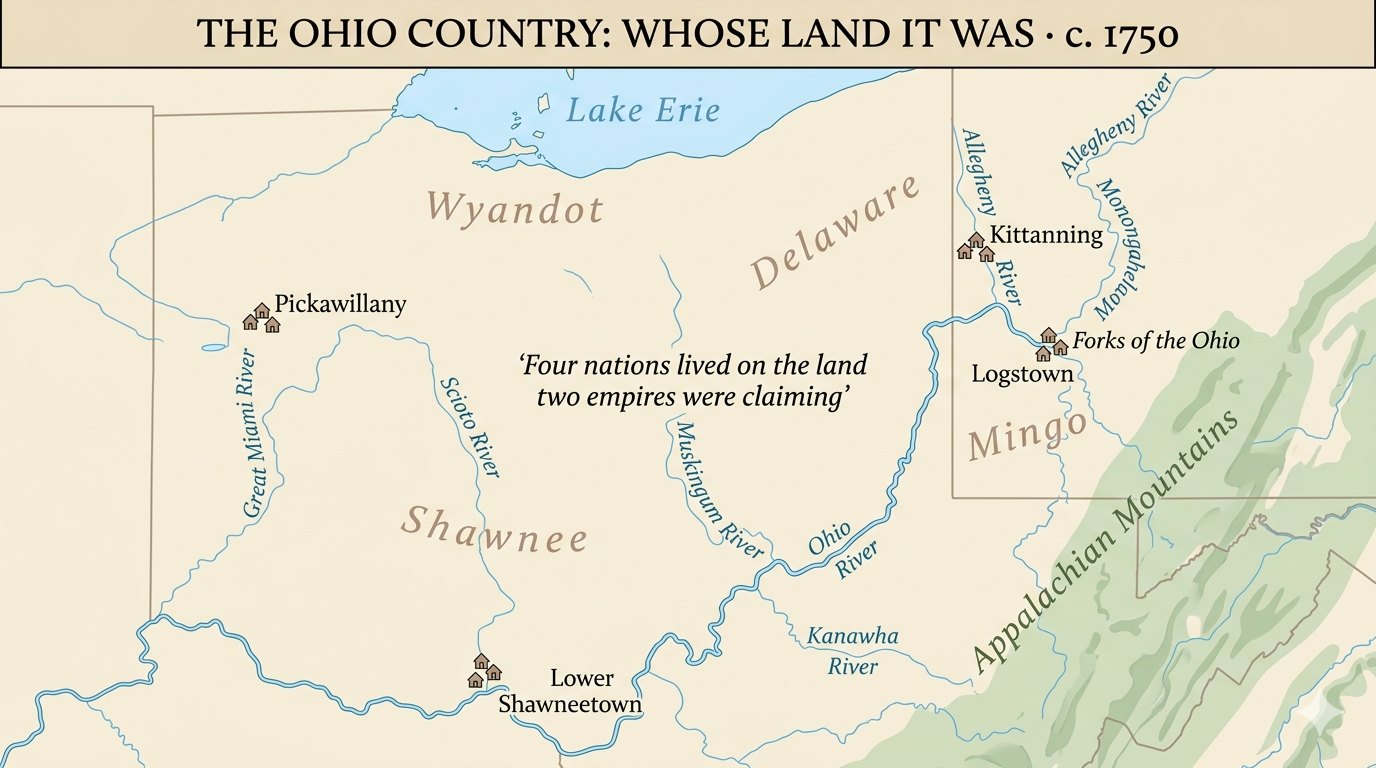
These were nations that had already fled colonial pressure once, settling new ground precisely because it was beyond the colonists' reach. The venture forming back east in Virginia existed for one purpose: to reach it.
A syndicate of planters and a king's signature
In 1748 a group of Virginia gentlemen organized themselves into the Ohio Company of Virginia. The founders were Thomas Lee and the brothers Lawrence and Augustine Washington, fronting the interest of a circle of Virginia, Maryland, and British investors in the Ohio Country. They were speculators, which is the polite name for people who buy land cheap on the bet that they can sell it dear later, and the Ohio was the bet of a lifetime.
A speculator's syndicate could not simply walk west and claim a valley, though. It needed a grant from the Crown. So a petition went across the Atlantic to King George II, and on the 16th of March 1748/49 (a date written with both years because Britain still used the old-style calendar, whose year began in late March, so a winter date carried the year on either side of that turn) royal instructions came back to Sir William Gooch, the Governor of Virginia, directing him to make the grant to two named men: John Hanbury, a London merchant who had done the lobbying at court, and Thomas Lee.
The numbers were enormous. The Crown granted 500,000 acres in the Ohio valley, the country lying between the Kanawha and the Monongahela Rivers, and it structured the grant in two parts. The Company got 200,000 acres up front, with a further 300,000 to follow if it met a condition. The condition is what mattered. To keep the land, the Company had to do two things. First, it had to seat one hundred settler families on the ground within seven years. Second, it had to build a fort, and pay to keep a garrison in it, at its own expense. In exchange, the land would be free of quitrent (the small annual feudal rent colonists owed the Crown) and free of tax for ten years. The Privy Council in London (the king's governing council) worked the paperwork through and the grant issued in mid-July 1749.
The grant ordered the Company to plant a hundred families and raise a fort on land where Shawnee, Delaware, Mingo, and Wyandot families were already living. The settlement condition and the dispossession are the same fact stated two ways. The Company existed to take that ground and sell it.
The roster of investors reads like a roll call of the Virginia gentry, and a few names matter for what comes later. Thomas Lee organized it. Lawrence and Augustine Washington were in, and so was their younger half-brother, a teenage shareholder named George Washington. George Mason joined and became the Company's treasurer in 1752. John Mercer and his sons held shares, and other tidewater shareholders besides, along with the London merchant John Hanbury, who had steered the petition through the Privy Council. And one more investor matters more than any of them for the chain of events to come: Robert Dinwiddie, the man who would soon be Lieutenant Governor of Virginia, held shares in the Ohio Company too.
By about 1750 the Company had put a foothold on the ground, a fortified storehouse at Wills Creek (near the present-day West Virginia and Maryland border), a forward base from which to push west.
The land rush and the king of the traders
The Ohio Company was not alone. The Ohio was the prize of the age, and other speculators wanted it too. The Loyal Company of Virginia organized at about the same time, a rival syndicate whose investors included Dr. Thomas Walker, William Cabell, and Peter Jefferson, the father of Thomas Jefferson. The two companies were after the same kind of thing: huge tracts of western land, won cheap, sold dear.
And the rivalry was not only between syndicates. Even on the British side the Ohio was contested ground. Virginia claimed it under its old sea-to-sea charter, a colonial grant that ran the colony's bounds clear across the continent; Pennsylvania claimed the same upper Ohio as a westward extension of its own charter. So the land race was never just Britain against France. It was Virginia's Ohio Company against Pennsylvania's traders, both reaching for the same Forks of the Ohio, and the Forks were the crux of the whole dispute.
Then there was George Croghan, the Irish-born Pennsylvania trader the frontier called the king of the traders, the British Empire's chief man among the Ohio Indians. In August 1749 Croghan bought 200,000 acres from the Iroquois, with one exception written into the deed: two square miles at the Forks of the Ohio, reserved for a British fort. The Forks were the key to the whole country.
Croghan's deed had a legal problem. Pennsylvania law barred private men from buying land directly from Native nations, which made his purchase invalid at home. Virginia practice was looser about such things, and so the king of the traders ended up working for Virginia's Ohio Company instead. By 1750 Croghan and the interpreter Andrew Montour were guiding the Company's scout, Christopher Gist, on a tour through the Ohio Indian villages, scouting the land the Company meant to sell.
Lead plates in the ground
France was watching all of this, and France answered first with ceremony and then with forts.
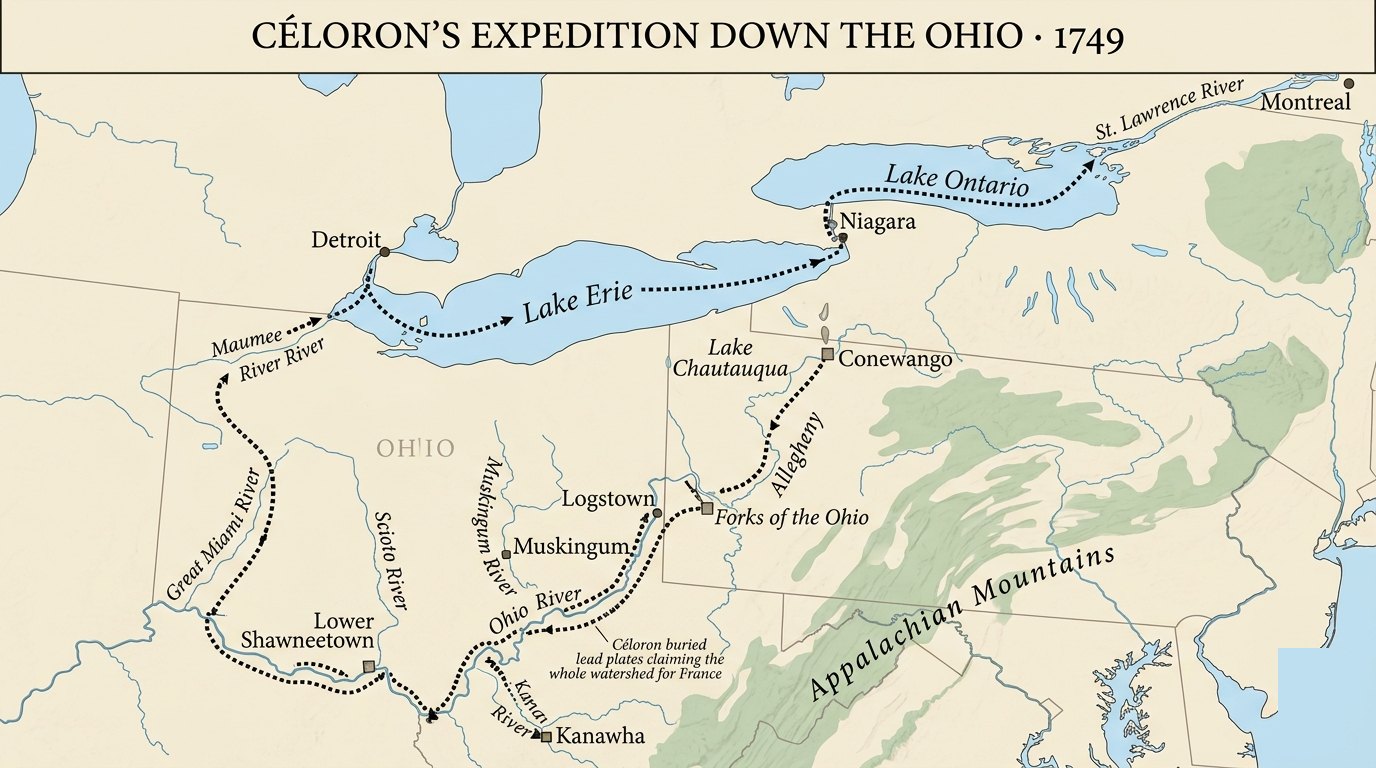
In the summer of 1749 the governor of New France sent an officer named Pierre-Joseph Céloron de Blainville down into the Ohio Country to reassert French ownership of the entire watershed and to drive British traders out of it. Céloron left Montreal on the 15th of June 1749 with a force of around 216 French Canadians and roughly 55 Native allies, somewhere near 270 men in all.
His method was strange and formal. At the mouth of each major tributary of the Ohio, Céloron's men buried an inscribed lead plate in the ground, a slab of lead about 11 inches by 7.5 inches, and nailed the French royal arms to a tree nearby. The plates claimed the land for King Louis XV of France. The text on them announced "the renewal of the possession we have taken of the said river Ohio and of all those which empty into it, and of all the lands on both sides as far as the sources." At least six of these markers went into the ground that summer, including one at the confluence with the Chadakoin on the 29th of July, one at the mouth of the Muskingum on the 15th of August, and one at the mouth of the Kanawha on the 18th of August.
"the renewal of the possession we have taken of the said river Ohio and of all those which empty into it, and of all the lands on both sides as far as the sources." — inscription on Céloron's lead plates, 1749
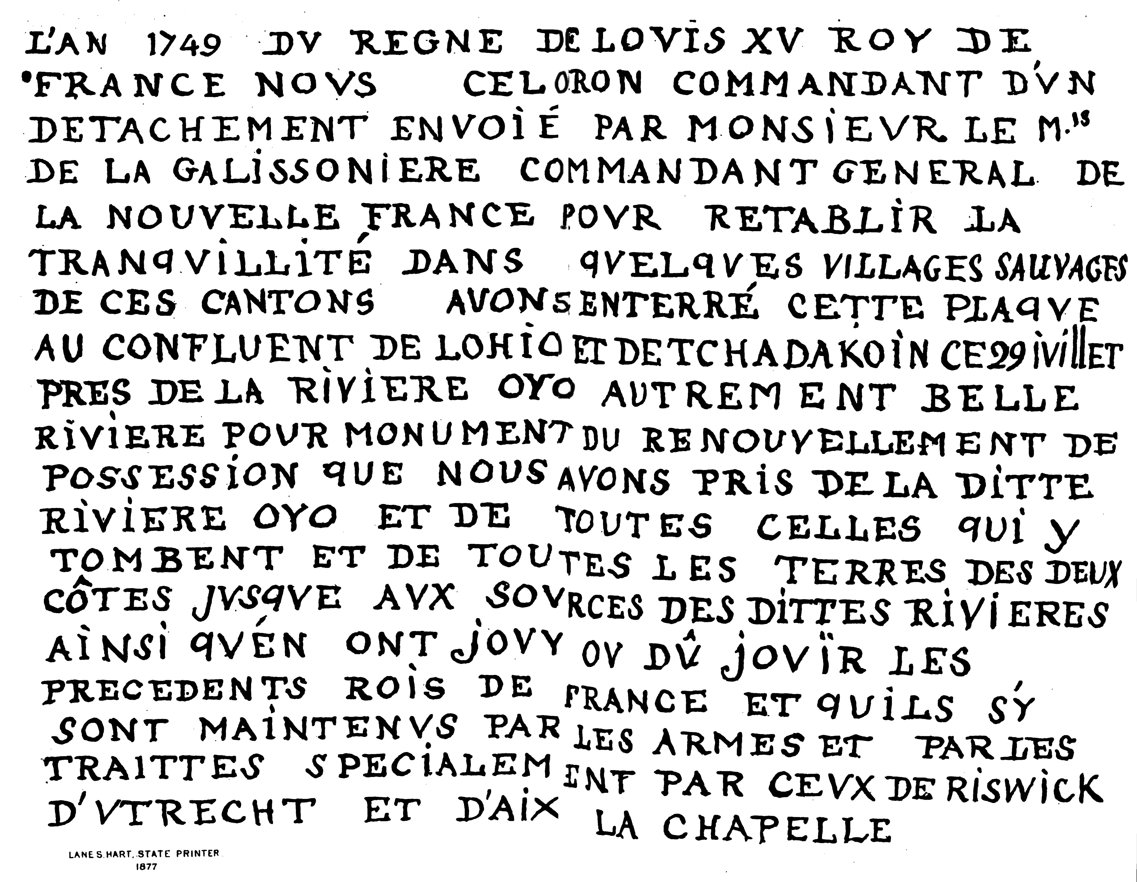
It changed nothing on the ground. When Céloron reached Logstown, a Native town on the Ohio, he found English traders doing business and ordered them out. Further down, near Lower Shawneetown around the 25th of August, he summoned the traders again and warned them to leave. They did not leave. Worse for France, Céloron's high-handed manner offended even the Iroquois traveling in his own party. Some of them peeled off and went home, and as they went they pulled the nailed French plates back down off the trees. The expedition returned to Montreal on the 10th of November 1749 having accomplished nothing durable. The British traders stayed. The Ohio nations were not won over. Céloron himself reported back that the nations of the Ohio were very badly disposed toward the French and devoted entirely to the English.
The lead plates are easy to laugh at, but someone is missing from the ceremony. France claimed the river and all the land on both sides of it as far as the sources, and at no point did anyone think to ask the Shawnee, the Delaware, the Mingo, or the Wyandot whose country it was. That silence is the same silence on the British paperwork. Two empires were trading away a land neither of them lived on.
A chain of forts toward the Forks
Ceremony had not moved the Ohio nations or cleared the traders out, so France reached for stone and timber. In 1753 and 1754 the French built a chain of forts to wall the British out of the Ohio and run a line of control from Lake Erie down toward the Forks. There were four, and they shared a design: a rectangle of roughly 75 by 105 feet with a bastion (a projecting corner platform for guns) at each of the four corners.
Fort Presque Isle came first, on the shore of Lake Erie at present-day Erie, Pennsylvania, with construction beginning on the 15th of May 1753. Next came Fort Le Boeuf, inland on French Creek at modern Waterford, Pennsylvania, begun on the 11th of July 1753. Fort Machault followed in August 1753, where French Creek meets the Allegheny at a place called Venango, present-day Franklin, Pennsylvania. The fourth and most important would come at the Forks of the Ohio itself, the fort that would be named Fort Duquesne.
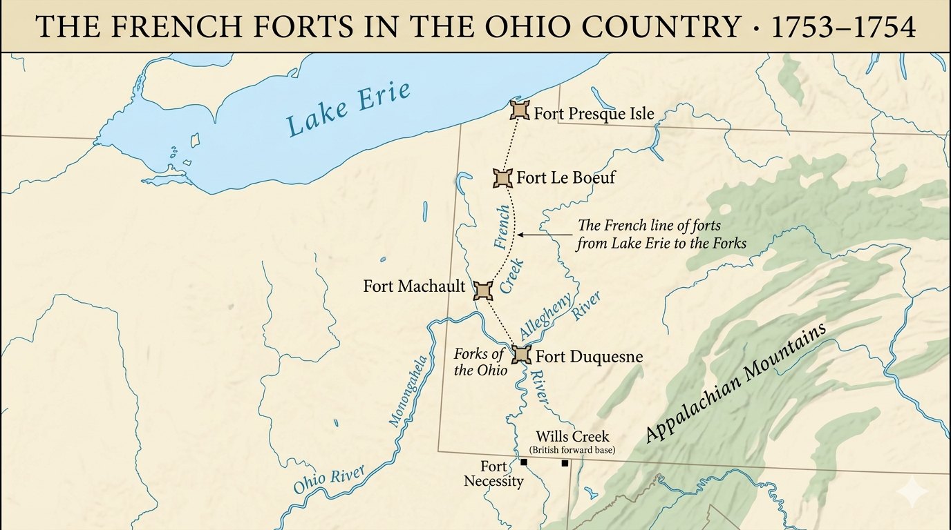
These forts were the last links in France's effort to connect Canada with the Illinois Country and Louisiana, the physical version of the land bridge. With them, France was no longer just claiming the Ohio. France was building the wall that would cut the British colonies off from the west for good. Virginia could not let that stand, and the man who would not let it stand was an Ohio Company shareholder.
An ultimatum carried by a 21-year-old
By 1753 Robert Dinwiddie was Lieutenant Governor of Virginia, and he was also a shareholder in the Ohio Company. The official sending an imperial ultimatum to France over the Ohio Country had a private financial stake in who ended up owning it. The empire's interest and the Company's interest had become, in Dinwiddie's person, the same interest.
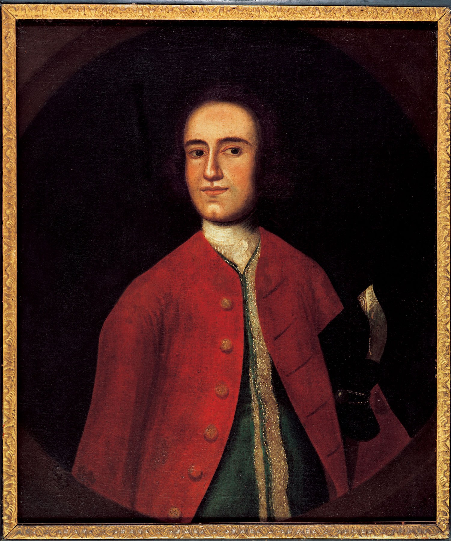
The envoy Dinwiddie chose was George Washington, then 21 years old, a major in the Virginia militia and, like the men who sent him, a shareholder in the Company whose land this was about. Dinwiddie commissioned him on the 30th of October 1753, and Washington left Williamsburg the next day. He hired a Dutch-born interpreter named Jacob Van Braam at Fredericksburg to handle the French, picked up the Ohio Company's scout and surveyor Christopher Gist at Wills Creek, and gathered four frontier traders to handle the baggage, along with Native escorts. His orders from Dinwiddie were to reach the French forces on the Ohio, present his credentials and deliver Dinwiddie's letter to the senior French officer, demand an answer, and along the way note everything he could about the French forts, their forces, and their intentions.
The party reached Fort Le Boeuf on the evening of the 11th of December 1753, escorted by Tanaghrisson, the Mingo leader the British called the Half-King, and other chiefs. Washington met the fort's commandant the next day. That officer was Jacques Legardeur de Saint-Pierre, and his answer, written out and dated from the fort on French Creek on the 15th of December 1753, was a polite, total refusal.
"As to the summons you send me to retire, I do not think myself obliged to obey it." — Jacques Legardeur de Saint-Pierre, French commandant, 15 December 1753
Saint-Pierre added that his orders came from his commanding general and that he would carry them out with all the exactness and determination that could be expected from a good officer, and that he knew of nothing in the campaign that could be construed as an act of hostility or as contrary to the treaties between the two Crowns. Which was diplomatic French for: we are not leaving, and you cannot make us.
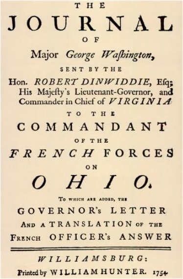
Washington left Fort Le Boeuf on the 16th of December and made the hard winter trip back, reaching Williamsburg around the middle of January 1754. He handed Dinwiddie the refusal and, with it, the journal he had kept on the road. That journal was published in Williamsburg in 1754 as The Journal of Major George Washington, and it made the unknown 21-year-old a name on two continents. It also recorded the voice of the man who had escorted him to the fort.
The land does not belong to either of you
The Ohio nations were never the backdrop. They were a third power, playing the two empires against each other to hold their own ground.
The man at the center is Tanaghrisson, also written Tanacharison, the leader the British called the Half-King. He was a Mingo, an Iroquois of Seneca background settled in the Ohio Country, and he first appears in the records at Logstown in 1747. Almost everything else about him is contested, and the contests matter. The French claimed he had been born a Catawba (a Carolina nation) and taken captive and adopted by the Seneca as a child, and some historians repeat that origin; others dispute it. His working identity, the one that counts here, was as a Mingo and Seneca spokesman in the Ohio. Even his famous title is disputed. The old reading is that the Iroquois Grand Council appointed him a deputy, a "half king," to oversee the Ohio peoples on the Confederacy's behalf. Modern historians argue that "Half King" was largely a British invention, a convenient title hung on a man whose real authority over the resident Ohio nations was thinner than the British wanted to believe. Both readings can be held at once, and the gap between them is the live question of who could sell the Ohio.
The Iroquois Confederacy claimed the whole country by right of conquest, won in the Beaver Wars a century before, and treated it as theirs to negotiate away to the British. But the people actually living on it, the four nations of the Ohio, did not accept that the Iroquois could sell their ground out from under them. The British, for their part, loved dealing through the Iroquois, and through the Half-King, precisely because it produced land cessions (formal handovers of land) that the resident nations had never agreed to. Buy the land from a council that did not live there, and you never had to ask the families who did.
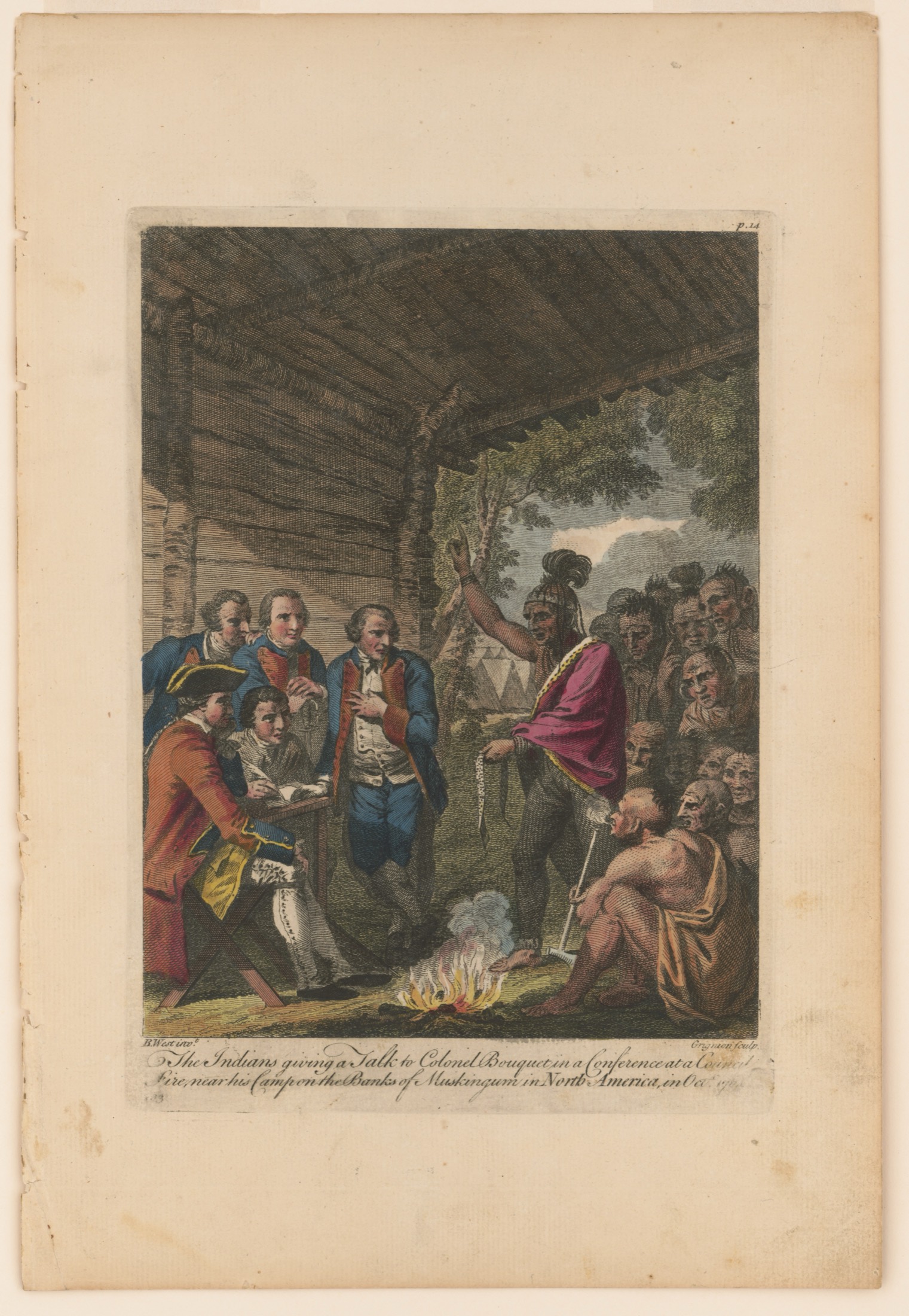
This came to a head at Logstown in June 1752. Logstown sat on the east bank of the Ohio about 14 miles below the Forks, near present-day Ambridge, Pennsylvania, and there Virginia's commissioners met the Six Nations. Virginia sent Joshua Fry, Lunsford Lomax, and James Patton; the Ohio Company sent Christopher Gist, William Trent, and William Beverley. Andrew Montour, who had guided Gist's 1750 tour, was the interpreter at the council, and he was treated as more than a translator: Tanaghrisson addressed him by his Indian name, Eghnisara, and spoke to him as a man with standing among them. The British came to get two things: a confirmation of the earlier 1744 Treaty of Lancaster, which the British read as ceding Native land beyond the Allegheny Mountains, and consent to a Company fort and Company settlements on the Ohio.
They did not get the first thing. Tanaghrisson flatly denied that the Lancaster treaty had ever ceded any land beyond the Alleghenies, and the Six Nations would not confirm Virginia's ownership of the country the Company meant to sell. Under pressure he did give ground on the second thing: he consented to a British "strong house," a fort, at the mouth of the Monongahela at the Forks, and promised the Iroquois would not trouble English settlements southeast of the Ohio. In fact he had been telling the Virginians as early as 1752 that they should build a strong house at the Forks. But he did not sign away the Ohio nations' country, and he was careful about exactly where the line fell.
The clearest statement of what the Ohio nations actually wanted survives because Washington wrote it down. Tanaghrisson is the person Washington quotes more than anyone else in his 1753 journal, and in it he recorded the Half-King's own speech to the French commandant. It is filtered through a British envoy's ear and pen, but it is the genuine primary record, and it says plainly what no empire wanted to hear.
"Both you & the English are White. We live in a Country between; therefore the Land does not belong either to one or the other; but the GREAT BEING above allow'd it to be a Place of Residence for us." — Tanaghrisson (Mingo), recorded in Washington's Journal, 1753
He was just as direct about the difference between trade and conquest:
"If you had come in a peaceable Manner like our Brethren the English, we shou'd not have been against your trading with us as they do, but to come, Fathers, & build great houses upon our Land, & to take it by Force, is what we cannot submit to." — Tanaghrisson (Mingo), recorded in Washington's Journal, 1753
And he threw France's own past friendship back in its face, calling the French the disturbers in this land, by coming and building their towns and taking it away unknown to the nations and by force. Two empires had each declared the Ohio theirs on paper. The man whose people lived on it told both of them, to their faces, that it belonged to neither.
Off the fieldThe Contest for Native AlliancesThe town France burned to make a point
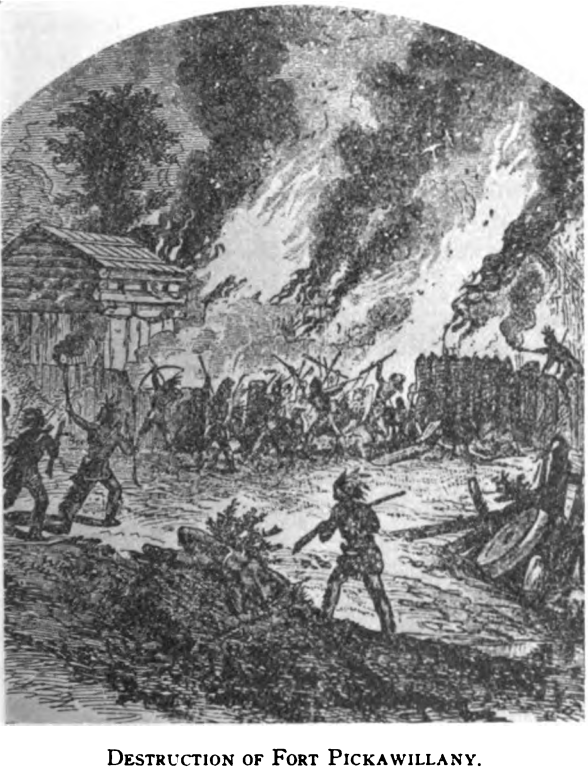
The Ohio nations were not only refusing land cessions in council. One of them had already gone further, choosing British trade over its French master outright, and the same June that Tanaghrisson stood at Logstown, France answered that choice with fire. The place was Pickawillany, a Miami (Twightwee) trading town on the west bank of the Great Miami River, near present-day Piqua, Ohio. The Miami chief Memeskia had founded it in late 1747 after breaking with the French, and within a few years it had grown to roughly 400 families and become the largest center of British trade in the whole Ohio Country. Memeskia had walked away from the French because their fur monopoly meant worse goods at worse prices, and he turned instead to Pennsylvania traders, the same Pennsylvanians reaching west under Virginia's rival. The British called him "Old Briton" for it; the French called him "La Demoiselle." His town undersold the French and pulled neighboring nations out of the French orbit, and France was watching that happen.
On the 21st of June 1752, days after the Logstown council, France moved. Charles Michel de Langlade, a young Métis officer in the French interest, led about 240 Ottawa and Ojibwe warriors down from the Great Lakes against Pickawillany, striking in the morning while most of the Miami men were away hunting. They killed about 13 Miami and an English blacksmith, captured several Pennsylvania traders, looted the goods, and burned the town. Memeskia was killed, and the attackers, by the accounts that come down to us, reportedly boiled and ate him within sight of the survivors, a deliberate act meant to punish his friendship with the English. The surviving Miami abandoned Pickawillany and drifted back toward the French. Historians often call the raid one of the opening actions of the war. France had shown it would use force to keep the Ohio nations in line, and Britain had shown it could not protect even the most prominent Native partner it had courted. The Ohio nations were choosing for themselves, and Pickawillany was what it cost when one of them chose wrong in France's eyes.
The race for the Forks
It all came down to one point on the map. The Forks of the Ohio, where the Allegheny and the Monongahela join to form the Ohio, sits where downtown Pittsburgh stands today, and it commanded river movement in every direction. Whoever held the Forks held the valley. The Ohio Company's grant had specifically ordered it to build its fort here, and Washington, scouting the site on his 1753 trip, had seen exactly why.
"As I got down before the Canoe, I spent some Time in viewing the Rivers, & the Land in the Fork; which I think extremely well situated for a Fort, as it has the absolute Command of both Rivers." — George Washington, Journal, 1753
Virginia moved first, barely. On the 17th of February 1754 a Virginia work party under Captain William Trent, with Ensign Edward Ward commanding on the spot, began throwing up a small fort at the Forks, called Fort Prince George, or simply Trent's Fort. It was a modest thing, and it did not last two months. A French force of 500 or more men under Claude-Pierre Pécaudy de Contrecoeur arrived at the Forks on the 17th of April 1754 and demanded surrender, and Ensign Ward, badly outnumbered, gave up the position without a fight the next day.
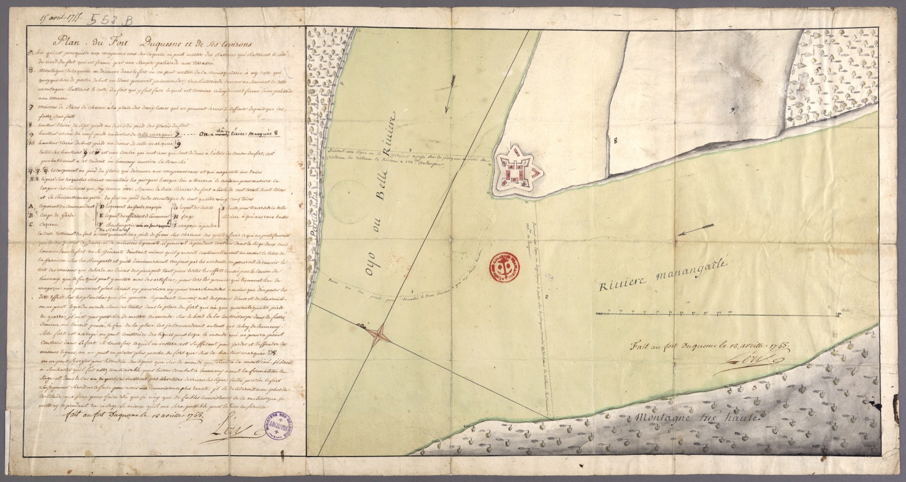
The French tore down the British work and built their own fort on the same ground, a far larger one, and named it Fort Duquesne for Ange Duquesne de Menneville, the Marquis Duquesne, governor-general of New France. Fort Duquesne became France's anchor on the upper Ohio. Within a year it would be the objective of a doomed British army marching west under Major General Edward Braddock, but that is another story.
The Ohio Company's charter ordered it to build a fort at the Forks. France built a fort on that exact spot first. The first shots of a world war would be fired over who owned that ground, and the ground was never empty: Shawnee, Delaware, Mingo, and Wyandot families were living on it the whole time. The real-estate venture and the war were not two things. They were one.
What was already being taken
The polite language of grants and treaties is built to hide what this was. The contest for the Ohio was a contest over Native land, and the people who lost it were the people who lived there.
The Ohio nations had already moved west once to escape colonial encroachment, and the Ohio Company was chartered to follow them and take the new land too: settle a hundred families, sell the rest. Their own aim was never to choose a European master. It was to keep both empires at arm's length and hold their ground, which is exactly what Tanaghrisson said in words Washington wrote down. Their leverage was real but bounded. They could refuse a land cession, as they did at Logstown. They could expel a trader or admit one. They could tip the balance between France and Britain by leaning one way or the other. But Pickawillany had already shown what that leverage cost when it pushed too far, and by 1754 both empires were building forts on their country anyway, with or without consent. The leverage was running out. The dispossession that the rest of this war would bring down on the Ohio nations was already visible, already in motion, before the war was even fully lit.
One more thing about the name. The colonists who fought this war called it the French and Indian War, naming it for the enemies they expected to face. The name centers their point of view and it flattens everyone else into one word. The Native nations were not one thing and not one side. They fought on all sides and, more than anything, for themselves, for the simple proposition that the land they lived on was a place of residence for them and not a deed to be signed away in Williamsburg or buried on a lead plate in Montreal's name.
The land grab came first. The war came after. And the families on the ground at the Forks were about to pay for both.
The first blood would be spilled within weeks, in two small fights along the same disputed ground. The opening shots came in a wet ravine where Washington's men and Tanaghrisson's fell on a French party.
The war storyJumonville GlenA month later the French answered, and Washington made his stand behind a hasty stockade in a mountain meadow.
The war storyFort Necessity