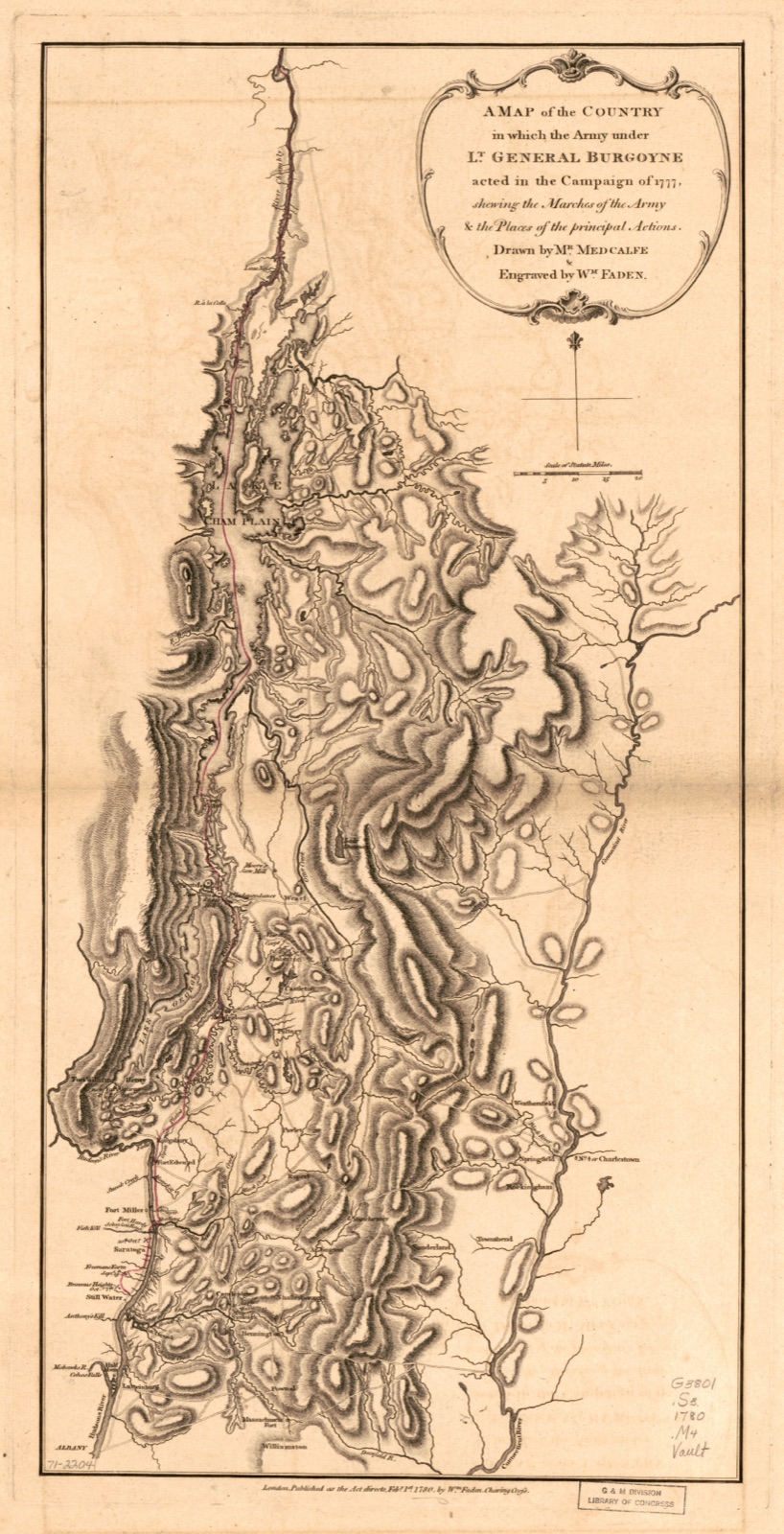
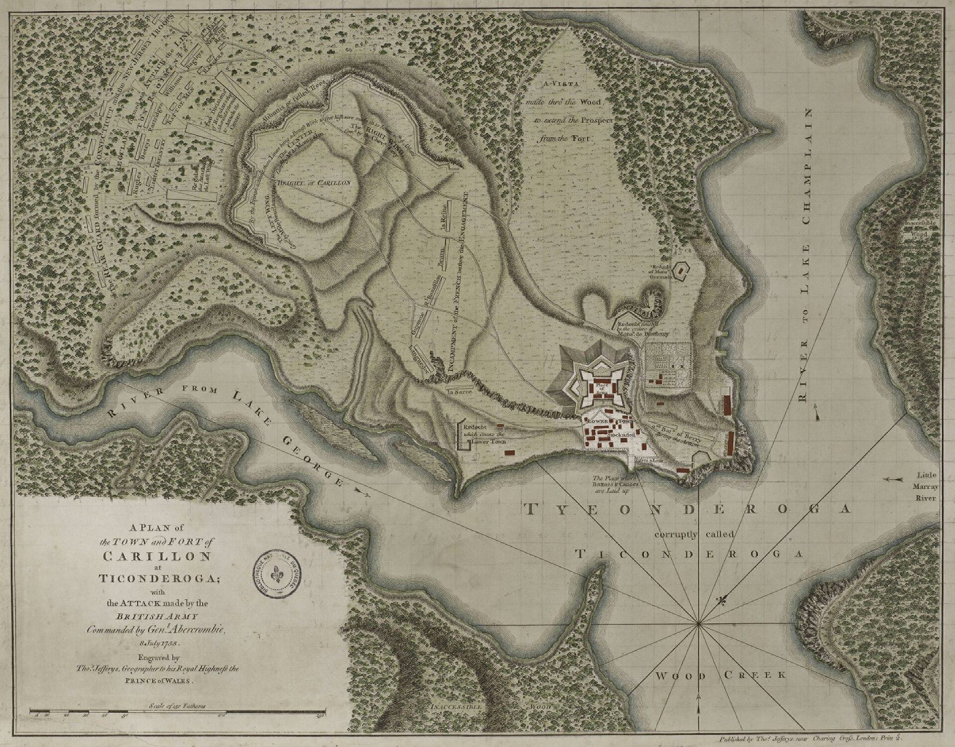
In the summer of 1777, Fort Ticonderoga was the most famous place in America. People called it the Gibraltar of the North, after the British rock fortress in the Mediterranean that was supposed to be impossible to take, and they meant it. The fort sat on a neck of land in upstate New York where two long lakes nearly touch: Lake George to the southwest, Lake Champlain running north toward Canada, and between them the La Chute River, a short, violent stream that drops 220 feet in about three and a half miles (the portage, the carrying-place where boats had to be dragged overland). Those lakes were the water highway between Canada and the American colonies, the natural invasion route in either direction, and the fort sat on the narrows like a hand on a gate. Whoever held Ticonderoga held the road.
By 1777 the place had already been famous twice. In 1758, when it was a French fort called Carillon, the largest army yet assembled in North America came up Lake George to take it and wrecked itself against a wall of logs, one of the bloodiest British defeats of the French and Indian War. One man in that doomed army had seen how to avoid all of it. Abercromby, the British commander, had an engineer named Matthew Clerk who pointed at a bare hill overlooking the French lines, a height the British called Rattlesnake Hill, and urged that cannon be hauled up it to fire down into the works. Abercromby ignored the hill, attacked head-on, and lost two thousand men. Remember the hill.
The second famous moment came in 1775, three weeks after the shooting started at Lexington, when Ethan Allen and Benedict Arnold surprised the fort's tiny British caretaker garrison (about 45 men) at dawn on May 10 and took the Gibraltar of the North without a battle, and Henry Knox sledged its cannon over the snow to Boston that winter. That story belongs to the war's opening act, and it is told there.
The war story1775: Allen and Arnold take the fort, and Knox takes its gunsNow came the third moment. In June 1777, Lieutenant General John Burgoyne (British) started south from Canada with an army built around roughly 7,100 regulars (full-time professional soldiers): about 3,981 British regulars, and about 3,116 Germans, mostly rented from the Duke of Brunswick (Americans called all the German troops Hessians, though most of these were Brunswickers), under Major General Baron Riedesel. With artillerymen, a few hundred Canadians and loyalists, and several hundred Native allies, the fighting force ran toward 8,000, and with camp followers the column passed 10,000 people, among them Riedesel's wife, the Baroness Friederike, traveling with their three small daughters.
The plan, approved in London, was the corridor strategy: Burgoyne drives down the Champlain line to Albany, a smaller force under Barry St. Leger swings down the Mohawk Valley as a diversion, and Britain takes control of the Champlain and Hudson waterway, cutting New England, the rebellion's furnace, off from the rest of the colonies. The plan also assumed something it never quite said out loud: that the main British army in New York City could cooperate on the Hudson when the moment came. Nobody in London ever turned that assumption into an order.
Burgoyne himself was a London celebrity: a cavalryman who had made his name on dashing raids in Portugal in 1762, a member of Parliament, a gambler, and a successful playwright, known to his men as Gentleman Johnny. He had sold the government this invasion personally and been given command of it over the general who ran Canada. On the way south he issued a proclamation to the Americans in his path, a magnificently pompous document threatening what would happen if they resisted, including the boast about his Native allies that the whole continent would shortly be laughing at, since the "thousands" were in fact a few hundred warriors.
but to give stretch to the Indian forces under my direction, and they amount to thousands
Waiting for all this at Ticonderoga was Major General Arthur St. Clair (American), a Scottish-born Pennsylvanian who had fought for Britain in the last war, and who had been in command of the fort for about three weeks. What he commanded was a famous name wrapped around a hollow position. The works were old and sprawling: the decaying stone fort, the 1758 French lines west of it, new redoubts (small enclosed forts of earth and logs), and a whole second fortress, a star fort on a hill called Mount Independence across the lake on the Vermont shore, linked to the New York side by a floating bridge a quarter of a mile long. Defending all of it properly needed something like 10,000 men. St. Clair's return counted 2,089 rank and file fit for duty, plus 124 unarmed artificers (military craftsmen) and about 900 short-term militia (part-time citizen soldiers called out for short stints). His own council of war put it at under 2,500 effectives (soldiers fit for duty). Washington and Congress had expected the year's main British blow to come north out of New York City, not south out of Canada, and the Northern Department under Major General Philip Schuyler, run from Albany, had been starved of men accordingly.
And the hill was still bare. Rattlesnake Hill, renamed Mount Defiance, 850 feet of rock just southwest of the fort across the mouth of the La Chute, stood about 1,400 yards from Ticonderoga and 1,500 from Mount Independence, close enough for cannon to reach both. The year before, John Trumbull, then a deputy adjutant in the northern army, had argued the hill commanded both forts and climbed it to prove the ascent was possible, taking Anthony Wayne, another of the army's officers, and a convalescent Benedict Arnold up with him; he concluded guns "could probably be dragged up." The warning was dismissed, mostly for the honest reason that there were not enough men to hold what was already built, let alone one more mountain. Nineteen years apart, two armies looked at the same hill and decided it could be ignored. The British had ignored it as attackers and paid two thousand men. The Americans were about to learn what ignoring it cost a defender.